Monsoon warnings issued across Thailand: Heavy rainfall and flash floods expected, says TMD

The northern and northeastern regions of Thailand are set to experience heavy rainfall, warns the Thai Meteorological Department (TMD). Across the country, 45 provinces, including Bangkok, have been alerted to be prepared for sudden flooding and flash floods, particularly in low-lying areas and near waterway passages. According to the forecast, it seems that an approaching southwestern monsoon which is becoming significantly stronger and already covering the Andaman Sea, Thailand, and the Gulf of Thailand is set to bring this deluge.
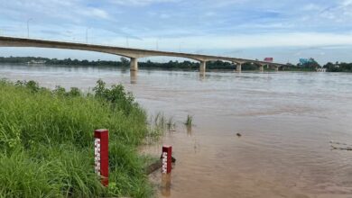
As the monsoon trough hits the upper part of Laos and Thailand, moving towards a low-pressure area over northern Vietnam, rainfall will increase across the country, potentially leading to heavy downpours in some areas. Conditions could be particularly challenging in the north, northeast, and east, with the threat of very heavy rain in some locations.
Communities in those regions are advised to be watchful of the danger from heavy to very heavy rain and accumulated rainfall which could cause sudden floods and flash floods. Particular caution should be taken in sloping areas near waterways and in low-lying areas.
At the same time, quite strong wind waves are occurring in the upper Andaman Sea and the upper Gulf of Thailand with wave heights about 2-3 metres in areas with thunderstorms. These waves could go beyond 3 metres in height. In the lower Andaman Sea and the lower Gulf of Thailand, seas have waves about 2 metres high, with more than 2 metres in areas with thunderstorms, hence sailors in these areas need to navigate with caution and avoid areas with thunderstorms.


For small boats in the upper Andaman Sea and the upper Gulf of Thailand, it is suggested to stay ashore during this period.
With regards to the weather forecast for Thailand, the north has thunderstorms with 80% coverage, with heavy to very heavy rain expected in some areas in Mae Hong Son, Chiang Mai, Lamphun, Lampang, Chiang Rai, Phayao, Nan, Phrae, Uttaradit and Tak provinces. The expected lowest temperature is between 24-26 degrees Celsius and the highest is between 29-34 degrees Celsius, with southwestern wind speeds of 10-20 kilometres per hour.
For the northeast, thunderstorms are covering 70% of the region. Areas to watch for very heavy rainfall include Loei, Nong Bua Lam Phu, Nong Khai, Bung Kan, Udon Thani, Sakon Nakhon, Nakhon Phanom, Mukdahan, Khon Kaen, Yasothon, Si Sa Ket, Amnat Charoen and Ubon Ratchathani. The expected lowest temperature is between 23-27 degrees Celsius and the highest is between 28-35 degrees Celsius, with southwestern wind speeds of 10-25 kilometres per hour, reported KhaoSod.
The central region has thunderstorms covering 60% of the area, with heavy rain expected in Kanchanaburi and Ratchaburi. The expected lowest temperature is between 24-27 degrees Celsius and the highest is between 33-36 degrees Celsius, with southwestern wind speeds of 10-25 kilometres per hour.
The east has thunderstorms covering 70% of the area, with very heavy rainfall expected in Nakhon Nayok, Prachin Buri, Chon Buri, Rayong, Chanthaburi and Trat. The expected lowest temperature is between 25-27 degrees Celsius and the highest is between 30-34 degrees Celsius, with southwestern wind speeds of 20-40 kilometres per hour. At sea, wave height is about 2-3 metres in areas with thunderstorms with waves possibly going beyond 3 metres in height.
The southern region on the east coast has thunderstorms covering 60% of the area, mainly in Phetchaburi, Surat Thani, Nakhon Si Thammarat, Pattalung, Songkhla, Pattani, Yala and Narathiwat provinces. In the upper part from Surat Thani upwards, the southwestern wind speed is 20-35 kilometres per hour with sea waves about 2 metres high, with more than 2 metres in areas with thunderstorms. In the lower part from Nakhon Si Thammarat downwards, the southwestern wind speed is 15-35 kilometres per hour with sea waves about 1-2 metres high, with waves more than 2 metres far from the coast.
On the west coast, the Southern region has thunderstorms covering 70% of the area and heavy rainfall in Ranong, Phang Nga, Phuket, Krabi, Trang, and Satun. The upper part from Phuket upwards, has southwestern wind speeds of 20-40 kilometres per hour, with sea wave heights of 2-3 metres and over 3 metres in areas with thunderstorms. In the lower part of Krabi downwards, the southwestern wind speed of 20-35 kilometres per hour with sea wave heights of about 2 metres, with more than 2 metres in areas with thunderstorms.
As for Bangkok and its vicinity, there are thunderstorms in 60% of the area. Temperatures range from 25-29 degrees Celsius to 32-35 degrees Celsius, with southwestern wind speeds of 10-30 kilometres per hour.
![]()
Join the conversation and have your say on Thailand news published on The Thaiger.
Thaiger Talk is our new Thaiger Community where you can join the discussion on everything happening in Thailand right now.
Please note that articles are not posted to the forum instantly and can take up to 20 min before being visible. Click for more information and the Thaiger Talk Guidelines.